
About Our Town
Yesterday
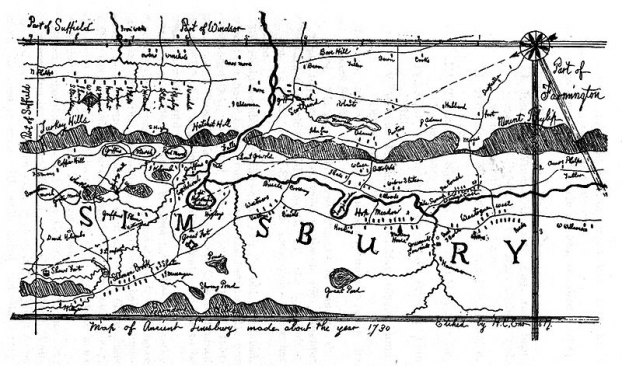
In 1670, John Case, who was the first constable in this area, along with Joshua Holcomb, presented a petition to the General Court that Massacoe become a town of the colony of Connecticut. On May 12 of 1670, the General Court granted the petition, and ordered that the plantation should be called "Simmsbury". The boundaries at that time were Farmington on the south, and Windsor on the east, with the extent of Simsbury running ten miles (16 km) north of Farmington and ten miles (16 km) west of Windsor, although the northern border, subject to dispute with Massachusetts, would be resolved later. This extent covers what is present day Simsbury as well as Granby and Canton.
The precise origin of the name of the town is not known for certain. Town records covering the first ten years after incorporation were accidentally burned in 1680. One possibility is that the name of Simsbury comes from the English town of Symondsbury. Joshua Holcomb, one of the colonies petitioners, originally came from Symondsbury. Another possibility is that the name was derived from Simon Wolcott. As he was known familiarly as "Sim" and he was considered one of the prominent men of the town.
In 1675, rumors of unrest among the indigenous peoples began to surface. The rumors proved accurate, and in the summer, King Philip’s War began, a war between a number of tribes, and the English settlers. The war extended through parts of four states, with Simsbury on the western edge of the conflict. At the time, it was seen as a frontier. The conflict was largely over by August 1676, although it did not formally end until a treaty was signed in 1678.
For more information on the history of Simsbury, click here.
Today
 | Simsbury lies in the northern end of the Farmington Valley. The east side of Simsbury, going toward the Capital city of Hartford, is flanked by Talcott Mountain, part of the Metacomet Ridge. This mountainous trap rock ridgeline stretches from Long Island Sound to nearly the Vermont border. Notable features of the Metacomet Ridge in Simsbury include Heublein Tower, Talcott Mountain State Park, Penwood State Park, and the Tariffville Gorge of the Farmington River. The 51-mile (82 km) Metacomet Trail traverses the ridge. At the western foot of the mountain, near the Farmington River, grows the Pinchot Sycamore, the largest tree in Connecticut.
|
The population in Simsbury has grown from 5,000 in 1950 to today's population of over 23,000. The town covers an area of approximately 34.5 square miles and is geographically located in Hartford County, approximately 14.5 miles west of the capital city Hartford. While Simsbury has experienced development in the past few decades, the Town government has been sensitive to maintaining the rural environment and historic charm that makes Simsbury the quintessential New England Community.
Special thanks to Alex P. a SHS Intern from FALP program for assistance on this web page.